
(Originally posted on LiveJournal)
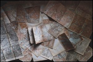 I was sorting through some stuff today, determining what I could throw out, what could get packed up and moved to the storage unit, and what I wanted to keep at hand. I ran across a box on an upper shelf in the hall cupboard, and pulled it down to check it. Oooo, boy, am I glad I did!
I’ve been working on my fantasy novel, The Ring of Adonel, and the story has lately been moving forward into “new territory”. In a sort of literal sense. The characters at last had moved out of territory that I knew well in my imagination, and they were moving into territory that (so far) I only knew by way of the maps I had created.
The problem was that I’d misplaced pretty much the only copies of the maps of the lands current with the story. There may be one set of copies somewhere in my papers, but I have no idea where they might be. The reason why having the maps is important, is that the distance scale is on them — so that I know how long it takes to get from point A to point B.
So, I needed the maps. And I found them! YAY! And promptly realized that the next major location the characters reach is actually still a couple of days away from where they are when I stopped working on the novel last month (a couple of other writing projects superceded it, for the present).
This got me to thinking about maps of imaginary places in general.
I love maps. Love, love, love maps. I’ve always loved geography. I find the subject almost endlessly fascinating. So, maps of fantasy places also intrigue me.
One thing that disappoints me in imaginary cartography are flat out errors of physical geography. Like rivers that go all the way through mountain ranges from one side to the other without explanation. Water only flows downhill, let us remember. Now, I’m not going to say that you can’t make an explanation — I, in fact, do have a river that sort of does that. But I know enough physical geography to create a geological history that allows for this particular river to flow this particular way (it includes some truly spectacular waterfalls, by the way).
Anyway… I have my maps! I’m going to need to scan them, so I have a record in case I misplace these precious papers again.
But, I’m happy to have found them.
Still, it’s also made me wonder about how everyone else views the matter of maps in fantasies.
Comments
sartorias – Nov. 20th, 2008
*love*
(As long as they are not yet another variation of Middle Earth)
scribblerworks – Nov. 20th, 2008
Okay, that’s a statement that intrigues me.
What makes for a “variation of Middle-earth”? Because I suspect it might be different for different people?
Is it lands that are shaped too much like Middle-earth’s? Or something like the squared-off, mountain-enclosed Mordor?
Elaborate, please! 🙂
sartorias – Nov. 20th, 2008
Some distortion of western europe, bad guys in the east, angels over the western sea. (There were a whole lot of these through the seventies and early eighties. They tended to be pretty predictable, so when I opened a book and saw such a map, I tended to think, uh oh, Tolkien shaped this story in the writer’s youth. I might do a page 97 test, and if the prose was not engaging, I’d pass. If it caught me, I’d read anyway, even if the general story turned out to be very much shaped by LOTR.
scribblerworks – Nov. 20th, 2008
*whimper*
I… slightly… resemble that remark! 😉
Although, in my case, the influence is more than just Tolkien. My genetic heritage is British, and so many of the motifs that I respond to are those that Tolkien did as well. The Blessed Lands lying to the west — be it Tir na Og or Avalon (or Tolkien’s Valimar or my own Kyradon).
Because of that, I tend to be a little more forgiving of the “pseudo-Europe” or Tolkien-influenced landscapes. What I find less generally acceptible is when I see more specific repetitions of Tolkien: the mountain enclosed “bad land” like Morder, or the protected gentle Shire-like homeland. Or “dwarf” kingdoms that are just too much like Moria (or Khazad-dum in its glory).
sartorias -Nov. 20th, 2008
Yep. I realize those things. I’m not saying I’m right, just my own reaction. (I never took to the Tir-nan-og tales when I was young, or the sagas–too much violence, too few interesting women, and little of the social tapestry that I like.) Anyway, that’s why I’ve always given the tales the page 97 test. If they have Tolkienish or a saga flavor, I tend to lose interest (especially if the names have apostrophes in them) but if there’s humor? I’m right on board. Person quirk.
scribblerworks – Nov. 20th, 2008
Fair enough.
Page 97, eh? I’ll keep that in mind. Heh.
lisa_marli – Nov. 20th, 2008
I love them. I just got the Tough Guide to Fantasyland, and as they put it, you can’t get around without your Map!
I do want the geography to make sense. The distance traveled to basically work. And if they travel too quickly, Why? Magic is acceptable, it’s a fantasy. Just don’t make them travel 200 miles in one day if they are walking.
And yeah, do not make it another Middle Earth Rip Off. Go rip off some other continent, or make up your own.
PS I also need to get your Guide to the Land of Myth. Are you coming to Loscon? I will usually be at the Mythcon table (hint, hint).
scribblerworks – Nov. 20th, 2008
What have you done to me????
There I was, so-so happily mulling over my financial situation, how to raise money and/or find a job (in Hollywood in this difficult season), and you dangle Loscon in front of me. Not that I should really spend the money on it…. but… reading through the panels lists–! *sigh* It’s now possible I will attend.
(As for a copy of my book — I have to open the last box and count how many I still have at hand. I need a certain amount for review copies still, but may have one or two I can – ahem – sell. 😉 )
Anyway, back to maps — yes! Distance is a big thing to me. I mentioned it on sartorias’ blog the other day, but having gone on a couple of trail hikes when I was in college, I have experience of what it’s like to walk a day’s distance (in mountains, no less), with a pack.
Nothing like actual experience to make such details come real to one.
lisa_marli – Nov. 21st, 2008
Heh, heh. You knew I was a con pusher when you met me. Goes with the book pusher that I can also be real good at. 😀
My daughter is currently complaining in her blog about how she is addicted to books. I start them with the fun stuff like Dr Seuss, then set the hooks with good children’s fantasies. I’m such a Good Mommy! It’s ok, she’s passing the addiction on. It is hereditary you know. 😉
Christopher is taking a Lord of the Rings Study module for his 1st year of High School English Literature, and it was his choice! Boasts his Very Proud Grandma!
muuranker – Nov. 20th, 2008
Hurrah for the finding of the treasure(d) map!
I have a motivational poster in my office, which I have up because I can’t believe it was distributed by my employer (along with much more conventional ones). It says ‘Those proud of keeping a tidy desk never experience the joy of finding what they thought irretrievably lost’.
I should say that at the office I _do_ have a tidy desk (I run a clear desk policy) but my natural tendency (which comes out at home) is towards mess.
scribblerworks – Nov. 20th, 2008
I love the sound of that poster! Hee.
I too managed to keep my desk at the office pretty clear. But I have so much stuff at home, and everything flows over everything else, it’s easy to misplace things. Partly because far too much of my stuff does not actually have a designated home: it just gets set down. I’m trying to address all that.
kalimac – Nov. 20th, 2008
I have lots of thoughts about maps, and I recently came across the map and fragmentary story of my early fantasy land, so I might write about that later.
Briefly, the first thing I look for in a fantasy map is: Do the countries on it exactly coincide with river drainage basins? If so, it’s no good.
scribblerworks – Nov. 20th, 2008
Well, I wouldn’t discount every imaginary country that was bounded that way — after all, there are some real countries that pretty much coincide with river drainage basins.
But, yes, rivers are more often borders.
Hmm. I wonder how much the oddity of the geography of the United States affects such things. When we think “nation”, Americans don’t necessarily think of river boundaries. If we thought “states”, it might be different, since so many states are indeed defined by river borders.
I hope you do write about you own fantasy land. I think it’s interesting to hear how other people started their own ventures into personal imaginary places.
danceswithwaves – Nov. 21st, 2008
Well, except for the states that were like “I want a straight border here!” *cough Pennsylvania* and another state was like “I want a straight border here!” *cough Delaware* and they both were like “what do we do with the extra? Oh no! Let’s give it to Maryland!”
kalimac – Nov. 21st, 2008
Hmm, no. Boundaries in the U.S. were almost all drawn before any white settlement came in; their choice was driven by lack of firm geographic knowledge, and they often wind up being at odds with the eventual settlement pattern, particularly when they run along rivers. (That the Portland, Omaha, St. Louis, Philadelphia, New York, etc. urban areas are split among states causes immense administrative headaches.)
A fantasy land should be built on indigenous settlement patterns. These may be seen in most of the national boundaries of Europe, where there are few river boundaries, and most of the ones that do exist are artificial. The indigenous groups do tend to settle in river basins, but they don’t take up the whole drainage area – just parts of it, and they may spill over to other drainage areas in an irregular fashion.
Compare European national boundaries to the drainage areas of the Rhine and the Danube, and you’ll see what I mean. Note, for instance, that the upper reaches of both rivers are part of the same country, Germany, but that Germany has sea access on neither river, the lower parts being taken up by other peoples, but it does extend to the sea on yet other rivers. Or compare the line between Spain and Portugal to the Iberian drainage patterns. Portugal doesn’t occupy any drainage basins: it’s a purely littoral country, and the explanation for this is buried in the history of the Reconquista.
scribblerworks – Nov. 21st, 2008
It’s been a long time since I’ve looked at historical geography, and the history of wider areas. Heh. I’ve usually been focused on the changes in one particular area. But you bring it back to me.
Actually, settlement patterns is perhaps my weakest area. I tailored my undergrad studies for fantasy & SF world building, but focused mostly on the physical (physical geography & geology). I took cultural anthropology, but that was mostly centered on the social interactions and not their environment.
Interesting.
asakiyume – Nov. 20th, 2008
Came here after seeing sartorias’s link 🙂
I think real geography is fascinating, and when maps and imaginary worlds reflect rules of real geography (e.g., one side of a mountain range gets lots of rain, the other side tends to be dry), I love that–makes it seem very real!
But, I only started noticing details like that as an adult; I suspect they’re more important to adult readers than young ones.
I love also the **styles** of maps in fantasy books–how mountains and forests and towns and things are represented.
Did you have fun drawing yours? I’ll bet yes….
scribblerworks – Nov. 21st, 2008
Welcome!
And yes, I did have fun drawing mine. One of them I attempted a topographical map, but I think I underestimated how much mountain one can fit in a particular space. 🙂
My first attempt at world building, I went a little crazy, and ended up creating the whole world. I had a huge map I created and put on my wall. I may still have a photo of it somewhere. But the map itself, I dispensed with, when that incarnation of my fantasy world got superceded.
The current version… well, I’ve limited myself to this one particular corner of the world. It seems to be enough.
alanajoli – Nov. 21st, 2008
I very much enjoy maps–more so when they make geographical sense! In some rpg work, it’s easy to notice how a fantasy world is being developed for the convenience of the world concepts, rather than actually obeying any reasonable laws of geography. 🙂 Having worked inside a couple of those (as a writer and a hobbiest), I always rejoice in maps that not only work for the story, but make sense for the physics and geography of the universe.
scribblerworks – Nov. 21st, 2008
Oh yes!
Part of my having this on my mind is that I recently got around to reading Paolini’s Eragon. Elements of that map made me crazy. And I don’t even mean the names in that case. Heh.
danceswithwaves – Nov. 21st, 2008
I love maps, too. Making and staring at them often helps me figure out more about my story world, too. Plus I use them constantly for distance and making sure my characters aren’t moving too fast, and so I know where they actually are.
I love maps in books I’m reading, too. It helps me visualize the area if I know where characters are and where they started from. Sometimes I need to have a “world view” when I’m reading, especially if characters travel, and it helps if there’s a map.
scribblerworks – Nov. 21st, 2008
Exactly!
Which was why I was so happy to find these maps. I really needed them, for just those matters of checking distance.
However, I’m also discovering in looking at them again, that they are also helping me visualize what the countryside will look like, when I come to describe it.